Debris flow and torrentPilot project

Rhaetian Railway – AI-based early warning system for the Carrerabach in Graubünden

One torrent, a 14 km² catchment, one of Graubünden's most important railway lines. Instead of measuring at the structure, we monitor the entire catchment – and extend the warning time from a few minutes to up to several hours.

Rhaetian Railway InterRegio on the Hinterrhein bridge in Graubünden
© RhB, photo: Andrea Badrutt, Chur

Together with the Rhaetian Railway and the Graubünden Office for Forests and Natural Hazards, GMD® monitors the 14 km² torrent catchment in real time as part of a pilot project – off-grid, year-round and without existing infrastructure on site.

Instead of measuring at the structure, the system detects an event where it begins to form.

Location: Carrerabach, Surselva / Safiental, Graubünden (CH) · Partners: Rhaetian Railway, Graubünden Office for Forests and Natural Hazards, Municipality of Safiental

Key project figures

Catchment
14 km²
Water level gauges
6
Weather stations
2
System availability
99.9%
Warning time
under validation
Rhaetian Railway line below an alpine torrent
© RhB, photo: Andrea Badrutt, Chur
Chapter 1

Background: a torrent above a railway line

The Carrerabach drains an alpine catchment in Graubünden and crosses the Rhaetian Railway line on its way. The combination is typical of the Alps: a steep channel carrying a lot of sediment above, a railway line below – infrastructure designed for a design event, not for every conceivable one.

The hazard picture has changed in recent years. Heavy rainfall events are becoming more frequent and more localised, precipitation intensities are rising and snowmelt starts earlier. Both increase the likelihood that runoff and sediment load change fundamentally within a short time.

The classic response is structural protection. It is necessary, but it does not answer one question: what is happening right now? A protective structure says nothing about its current condition – not about how full the sediment retention basin is, not about a blockage forming, not about how precipitation is developing in the upper catchment.

This is exactly the gap the monitoring system closes.

Terrain survey of the Carrerabach catchment
Terrain survey of the catchment · © GMD® GmbH
Chapter 2

Why the entire catchment is monitored

14 km² sounds manageable. For early warning, however, this size is the decisive factor – in both directions.

The challenge

In a catchment of this size and steepness, the time of concentration is short. Between a heavy rainfall event in the upper area and the peak discharge at the crossing structure there are not hours, but often minutes to a few tens of minutes. If you only measure at the structure, you learn about the event when it is already on its way. That is not enough for an orderly operational response – train dispatching, closure, staff deployment.

The opportunity

An area of this size can be instrumented with a high sensor density. Across several hundred square kilometres, area-wide sensors would not be economically viable; at 14 km² they are. This shifts the moment of detection from the event to the formation of the event.

GMD® has therefore captured the area not at one point but as a system: precipitation in the upper catchment, water level in the channel, snow depth at the relevant altitudes and visual checks at critical channel sections. The warning does not come from a single reading, but from how they interact.

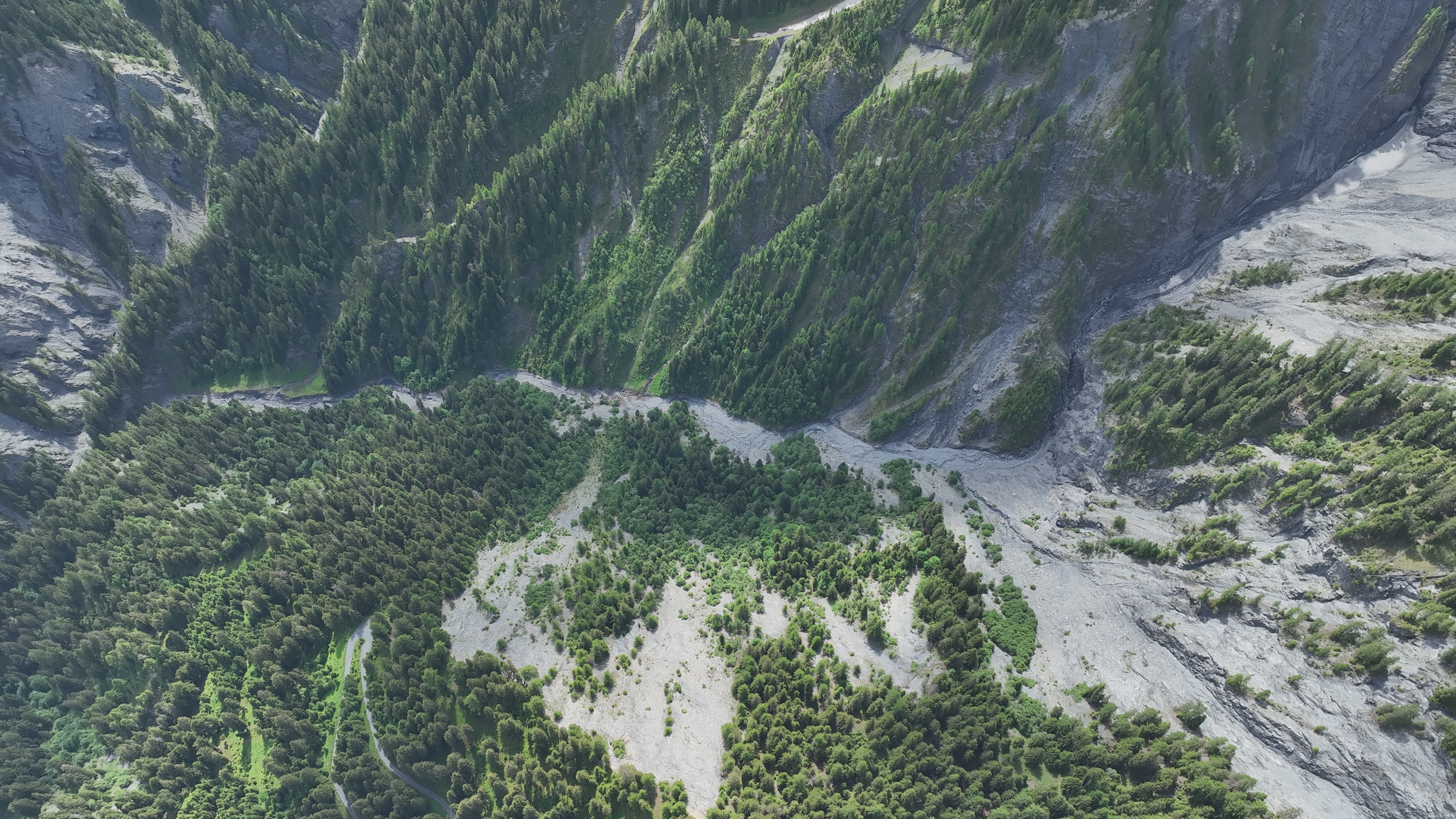
Image from the Carrerabach pilot project
© GMD® GmbH
Chapter 3

What an event means for rail operations

For an infrastructure operator, a debris flow is first and foremost not a damage event but an availability event. Material damage to the structure is usually insured and repairable. What cannot be replaced is operating time.

The typical sequence after an event on an alpine railway line:

  1. Immediate closure of the affected section
  2. Rail replacement by road, provided the road itself is passable
  3. Clearing sediment, driftwood and debris from the track
  4. Inspection of the substructure, drainage and adjacent structures
  5. A decision to reopen, with the open question of whether further slides are to be expected

Each of these steps takes time. The last one takes the longest, because without data it can only be answered conservatively: when in doubt, the line stays closed.

Monitoring helps before, during and after an event

  1. Before the event

    Warning time

    It enables a planned rather than an improvised response.

  2. During the event

    Situation overview

    Incident command does not have to piece it together from individual reports.

  3. After the event

    Reopening

    If the sensors keep running, it is clear whether the situation has calmed down – the data basis for the decision to reopen.

This third point is regularly underestimated when early warning systems are assessed, and it is often the largest single item in economic terms.

Chapter 4

System design at a glance

The monitoring system at the Carrerabach consists of four layers that build on each other.

GeoSenseAI® view of the Carrerabach catchment with measuring points
GeoSenseAI® platform · © GMD® GmbH
  1. Layer 1

    Field sensing

    Self-powered sensor nodes continuously measure hydrological and meteorological parameters at defined locations in the catchment – without grid connection and all year round.

  2. Layer 2

    Transmission

    A mesh IoT radio network links the sensor nodes. If a node fails, the network routes the data along an alternative path.

  3. Layer 3

    Analysis

    GeoSenseAI® combines the measurements with high-resolution weather forecasts and hydrological models, continuously assesses developments and maintains a digital twin of the catchment.

  4. Layer 4

    Warning

    When defined thresholds are reached, warnings go out automatically to the defined recipient groups – with measuring point, value, trend and forecast.

Redundancy instead of single measurements: no warning relies on a single sensor. What counts is a consistent picture from several independent measured variables.

Non-contact radar water level sensor above the Carrerabach channel
Radar water level sensor at the Carrerabach · © GMD® GmbH
Chapter 5

Radar water level measurement: non-contact and winter-proof

Water level is the key hydrological variable – and in a torrent the hardest to measure reliably. Pressure probes in the channel are damaged or buried by sediment, float gauges need a gauge house, and ultrasound is sensitive to temperature layering and spray.

At the Carrerabach, GMD® uses non-contact radar level sensors. They are mounted above the channel and measure the distance to the water surface from the travel time of a radar signal.

Advantages in torrent operation

  • No contact with the water: sediment, driftwood and ice cannot damage the sensor.
  • Insensitive to ambient conditions: fog, spray, snowfall and temperature layering have no relevant effect on the measurement.
  • Operational all year: no icing of the measuring point, no maintenance trips in winter.
  • High measurement frequency: readings at intervals of under 30 seconds, so that even rapid rises are captured without gaps.

What is analysed is not the absolute value but the trend: the rate of rise, its acceleration and the deviation from the behaviour expected for the current precipitation.

Technical data

Measuring principleRadar, non-contact
Measuring range0.1–50 m
Resolution1 mm
Interval, normal operation30 seconds
Interval, event mode10 seconds
Protection classIP67 / IP68
Self-powered GMD® weather station in the Carrerabach catchment
Self-powered weather station in the catchment · © GMD® GmbH
Chapter 6

Weather stations: measuring the cause, not just the effect

Water level and flow velocity are effect variables. They show that something is happening – not that something will happen. The upstream variable is primarily precipitation.

A regional weather station is not enough for this: alpine heavy rainfall is highly localised. A thunderstorm cell can drop 40 millimetres in an hour over a sub-catchment while the nearest official station a few kilometres away records hardly any rain. For assessing the Carrerabach, what matters is what falls within the catchment itself.

GMD® therefore operates its own self-powered weather stations in the area.

Parameters recorded

Precipitation amount and intensity Air temperature Relative humidity Wind speed and direction Air pressure Snow depth

From pilot project to regular operation

Validating the system at the Carrerabach is the basis for moving the concept into regular operation. We chose this catchment deliberately: its complex topography, dynamic runoff behaviour and demanding weather conditions make it one of the toughest test sites in the Alps.

That toughness is intended. Only under extreme conditions can we show whether installation, connectivity and measurement quality work reliably when it really matters – a quality promise we want to prove to ourselves out of conviction.

Catchment monitoring instead of measuring only at the structure – transferable to any torrent crossing with similar characteristics.

Combined with weather forecasts and a digital twin, the methodological core is not tied to one site. In the Alps alone, this applies to several thousand sections of line.

We thank the Rhaetian Railway, the Graubünden Office for Forests and Natural Hazards and the Municipality of Safiental for the opportunity to test our system under these demanding real-world conditions. This shared trust in a pilot project is the foundation on which a future standard solution for the Alps can be built.

A torrent crossing on your network?

We'll show you how the Carrerabach approach can be applied to your line or site.