Early warning systems for heavy rainfall and floods

Radar sensors monitor water levels, inflows, and slope movements in real time. Automatic alerts help warn and protect communities and critical infrastructure.


Climate change: Increasing risk of heavy rainfall

During extreme rainfall monitoring is crucial

Heavy rainfall is becoming more frequent: water levels rise within minutes, slopes become unstable, and landslides or debris flows can occur. Without reliable data, emergency response often comes too late.

Your benefits with GMD®:

  • Continuous measurement of critical parameters
  • Automatic risk assessment on the GeoSenseAI platform
  • Targeted alerts via SMS, email, or app

This gives municipalities and infrastructure operators valuable time to close roads and paths, reroute traffic, or evacuate areas in advance.

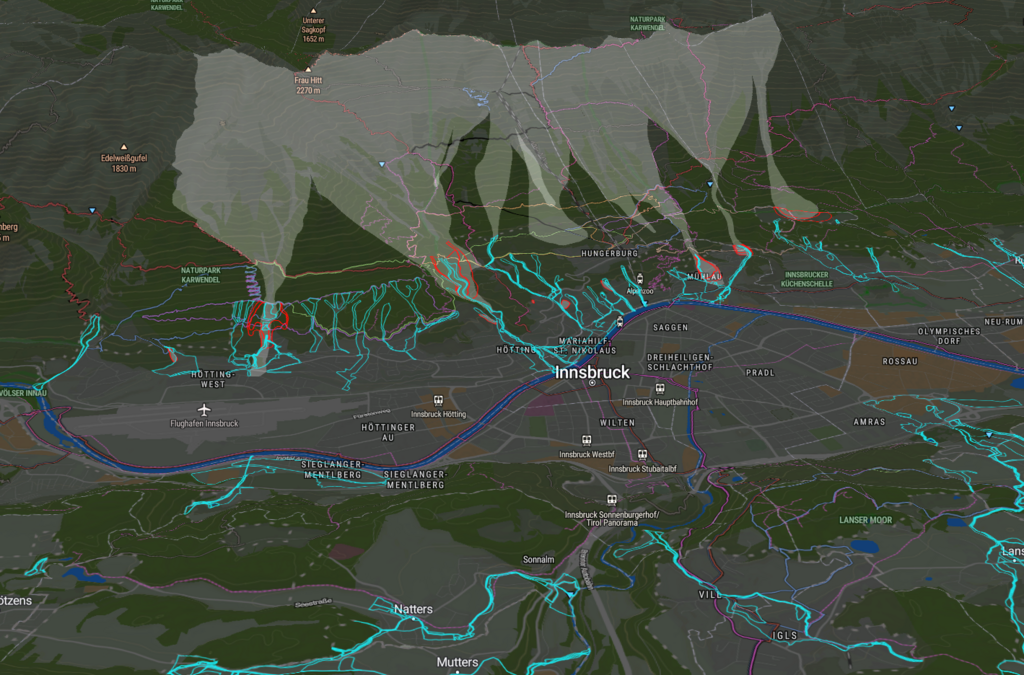
Screenshot von GeoSense AI Plattform der Innsbruck und die Nordkette zeigt: Anschwellende Bäche und steigene Pegelstände in Echtzeit
Real-time monitoring on the GMD® platform: Keeping rising streams and water levels under control

Effective flood early warning

Three steps to reliable preventive measures against the impacts of heavy rainfall, such as floods, landslides, or debris flows: Ensuring safety for municipalities and infrastructure operators.

Measure

Water levels & inflows, slope movements, precipitation (radar, ultrasound, pressure, seismic, tilt)

Assess

AI-powered risk analysis with thresholds, trends, and anomaly detection

Alert

Automatic warnings via SMS or email; live situational overview & documentation in the dashboard

Benefits for municipalities & operators

Extreme rainfall and debris flows are among the greatest risks. With GMD® sensors and the AI-powered platform, you gain valuable lead time for protection and planning.

Time advantage

React minutes earlier instead of being caught off guard

Targeted action

Close, reroute, or evacuate based on real-time data

Proof & planning

Event data as documentation for funding and support for future protection concepts

Robust & autonomous

Operates even in extreme weather conditions (solar/battery, IP67/68)

High-risk areas for floods & landslides

Key scenarios for natural hazard monitoring

While heavy rainfall and debris flows can occur anywhere, they are most critical when infrastructure, access roads, or settlements are at risk. These are the points where we deploy our sensors.

Streams & bridges

Monitoring rising water levels during heavy rainfall and snowmelt

Steep slopes & gullies

Landslide early warning based on slope movements and rainfall

Settlements & access routes

Protection for roads, villages, and supply facilities

Making natural hazards visible

Technical facts on GMD® sensors

Our sensors are designed for use under extreme conditions. They precisely measure water levels, inflows, ground movements, and precipitation, transmitting the data in real time to the GeoSense platform. Depending on the location and hazard scenario, we combine different sensor types, communication channels, and power sources.


GMD® water level sensor with flow velocity and blockage detection


Sensors for flood & landslide monitoring

GMD® systems combine different sensor types to ensure precise and reliable detection of hydrological and geotechnical changes. Depending on the location and risk profile, the following technologies are used:


  • Water level & flow measurement (Hydro Unit)
    • Radar sensors for non-contact, millimeter-accurate water level measurement
    • Ultrasonic sensors to monitor flow velocity and stream behavior
    • Pressure sensors for hydrostatic water level measurement (e.g. in shafts, reservoirs)

  • Water quality parameters (optional): Temperature, conductivity, and turbidity sensors to assess meltwater or flood runoff

  • Slope & ground movements (Seismic Unit)
    • Seismic sensors to detect micro-vibrations and early signs of debris flow risk
    • Inclinometers for continuous tilt monitoring on slopes and protective structures

  • Measurement accuracy
    • Water level: ±2 mm
    • Flow velocity: ±0.1 m/s
    • Temperature: ±0.1 °C


With this modular system, GMD® covers the full range (from hydrological parameters to geotechnical early indicators) tailored to each heavy rainfall and flood scenario.

Sensor accuracy for flood and landslide monitoring

GMD® sensors are engineered for maximum precision to reliably detect critical changes:


  • Hydro Unit: sensors for (flood) water monitoring
    • Water level measurement with an accuracy of ±2 mm
    • Flow velocity precise to ±0.1 m/s
    • Temperature measurement with deviation < ±0.1 °C

  • Seismic Unit: sensors for ground and slope movement
    • Sensitivity <0.01 mg (micro-gal) to detect micro-vibrations
    • Frequency range from 0.1–100 Hz for landslide and seismic event detection
    • Dynamic range up to 120 dB for detailed analysis

  • Reliable under extreme conditions
    • Robust design (IP67/IP68) for use during floods, heavy rainfall, or frost
    • Autonomous operation via solar or battery systems
    • Edge AI for real-time data validation and automatic anomaly detection


With this level of accuracy, GMD® Hydro and Seismic Units enable early detection of heavy rainfall and flood hazards, reduce false alarms, and provide a solid basis for decision-making by municipalities, emergency services, and infrastructure operators.

Energy supply for flood & land slide monitoring sensors

The GMD® Hydro and Seismic Units are designed for autonomous, long-term operation in remote or hard-to-reach areas:


  • Independent power supply
    • Solar or battery operation with up to 60–72 months runtime without external power
    • Low-power technology for efficient continuous operation


  • Field reliability
    • Stable performance even during extreme weather such as heavy rainfall, flooding, frost or snow
    • Reduced maintenance effort thanks to robust design and remote servicing


This ensures GMD® systems remain fully operational in alpine regions without costly infrastructure or ongoing energy expenses. Municipalities in valleys or outside the Alps also benefit from lower maintenance needs and reliable 24/7 monitoring.

Communication for real-time flood and hazard monitoring


GMD® systems transmit measurement data in real time – stable and reliable, even from remote mountain regions or hard-to-reach valleys.

  • Multiple transmission paths (depending on location and availability)
    • LoRaWAN for energy-efficient long-range transmission
    • LTE-M / NB-IoT for mobile networks
    • Satellite communication for sites without network coverage

  • Seamless integration
  • Security & reliability
    • End-to-end encryption for secure data communication
    • Edge AI for preprocessing and real-time analysis directly at the sensor


This ensures that early warnings and alerts reach exactly where they are needed and without delay, in alpine regions, urban areas, or emergency service and authority centers.

Automated alarming for flood and hazard early warning

GMD® systems detect critical changes at an early stage and trigger automatic warnings when needed.


  • Multi-channel notification
    • Alerts via SMS, email, or app notification
    • Interfaces for control centers, emergency services, and authorities

  • Customizable
    • Escalation levels by hazard type (pre-warning, alert, emergency)
    • Flexible configuration for municipalities, infrastructure operators, or utilities

  • Fast & reliable
    • Immediate triggering without delay
    • End-to-end secure transmission of alerts


This ensures that decision-makers and emergency services are informed in time to take immediate protective and damage prevention measures.

Prevent natural hazards

Is your community prepared?

We identify risks from water levels, slopes, and heavy rainfall and provide early warnings before hazards escalate.